The problem in one sentence
Maritime domain awareness is the practice of knowing what is on, above, and below the water, and what it intends to do. The phrase covers everything from a coast guard watch floor tracking fishing fleets to a navy operations center holding a picture of a contested strait. The ocean is the largest surveillance problem on Earth, and the sensors are no longer the bottleneck — the software between them is. That inversion happened quietly over the last decade, and it is the reason so much federal investment now flows to software firms rather than sensor manufacturers.
Twenty years ago the constraint was collection: not enough radar coverage, not enough acoustic arrays, not enough revisit from space. Today commercial radar satellites image every ocean on a schedule, hundreds of thousands of vessels continuously self-report their positions, and acoustic sensing produces more recorded hours than any human team could review. The picture is drowning in its own inputs. Detection, association, triage, and presentation — classic software problems — decide what a watchstander actually sees.
The sensing layers, and what each one asks of software
It helps to think of the maritime picture as five layers, each with a distinct software burden.
| Sensing layer | What it observes | The software problem |
|---|---|---|
| Space-based radar (SAR) | All-weather, day-night surface pictures over wide areas | Detection at scale; separating vessels from sea clutter, wind streaks, and islands; doing it across thousands of scenes |
| Ship transponders (AIS) | Self-reported identity, position, course, and speed | Gap analysis, spoof detection, and cross-checking self-reports against independent sensing |
| Undersea acoustics | Quiet contacts below the surface | Pulling low-signal contacts out of ocean noise; keeping operator review economical |
| Shore and shipboard radar, EO/IR | The local tactical picture | Small and low-signature targets in sea clutter; sensor handoff as contacts move between coverage zones |
| Environmental data | Ice, weather, sea state, currents | Fusing forecast products into routing and sensor-performance prediction |
No single layer answers the awareness question. Radar sees a vessel but not its name. Transponders report a name but only for ships that choose to transmit. Acoustics hears what neither sees. The value concentrates where the layers are joined — which is a data-engineering and inference problem, not a physics problem.
The transponder layer and the dark-vessel problem
The Automatic Identification System is the closest thing the ocean has to a public flight tracker. Under the International Maritime Organization's SOLAS Chapter V carriage rules, ships of 300 gross tonnage and up on international voyages, larger domestic cargo ships, and all passenger ships must carry and operate AIS; the requirement has been in force fleet-wide since the end of 2004. The result is a continuous, global, machine-readable feed of vessel self-reports — and one of the most useful public datasets in the maritime world.
Its weakness is the word "self-reported." A vessel that wants to disappear can switch its transponder off, and a vessel that wants to deceive can transmit a false identity or position. The vessels that go silent — "dark vessels" in the common shorthand — are disproportionately the ones worth watching: illegal fishing fleets, sanctions evaders, smugglers. Finding them means comparing what the transponder layer says against what an independent sensor actually observed. That comparison is a pure software product: correlate radar detections against AIS tracks, flag the detections with no matching self-report, rank them for a human.
The public benchmark for this problem is xView3-SAR, released in 2021 by the Defense Innovation Unit and Global Fishing Watch: nearly a thousand analysis-ready radar scenes from the European Sentinel-1 mission, labeled for vessel detection and fishing activity. It made dark-vessel detection a reproducible machine-learning task with public leaderboards, and it remains the reference point for anyone claiming performance in this space. When a firm says its detector finds dark vessels, the first question worth asking is how it scores on that public benchmark.
Space-based radar at scale
Synthetic aperture radar earned its place in the maritime picture because it does not care about clouds or darkness. A radar satellite images a shipping lane at midnight in a storm as readily as at noon in clear weather. With multiple commercial constellations now selling imagery alongside free public missions, coverage is no longer scarce — but a human analyst can meaningfully review only a tiny fraction of the scenes collected over an ocean basin.
So the software burden is industrial-scale detection with disciplined false-alarm control. Sea clutter, breaking waves, small islands, offshore infrastructure, and image artifacts all masquerade as vessels. A detector that produces ten false alarms per scene is useless at a thousand scenes per day, because triage capacity is the scarcest resource on any watch floor. The engineering that matters is less the model architecture than the evaluation discipline: performance measured across sea states, vessel sizes, and geographies, with the false-alarm budget stated up front.
Undersea acoustics: software on top of physics
Below the surface, the picture belongs to acoustics, and the physics is unforgiving. Sound is the only signal that travels usefully underwater, the ocean is loud, and the contacts of interest work hard to be quiet. Classical sonar signal processing — beamforming to steer arrays, filtering to isolate narrowband tones, normalization to stabilize noise floors, detection thresholds tuned to keep false alerts manageable — is a mature, published discipline that has run on naval systems for decades.
What has changed is the review economics. Modern arrays produce more channels and more recorded hours than trained operators can screen, and operator attention is the binding constraint. The published research direction is consistent: use learned models to pre-screen and prioritize — surface the intervals and bearings most likely to hold a real contact — while keeping the human on the classification decision. The open literature is equally consistent about the hard part: labeled undersea data is scarce, environments shift from one ocean to another, and a model trained in one basin degrades in the next. Any serious effort in this space is as much about evaluation methodology and data curation as about the model.
Tracking: the unglamorous core
Detection gets the attention; tracking does the work. A maritime picture is not a pile of detections — it is a set of maintained tracks, each one a hypothesis that a series of observations over hours or days belongs to the same physical vessel. Multi-target tracking in clutter is one of the oldest problems in applied estimation, and its difficulty scales brutally with density: a congested strait can hold thousands of simultaneous contacts, crossing, merging, anchoring, and maneuvering.
The software problems are association (which detection belongs to which track), initiation and termination (when to open a track, when to let one die), and identity persistence across sensor gaps. A vessel that leaves one radar's coverage and appears in another's an hour later should be one track, not two. Filters and motion models handle the kinematics; the modern additions are learned motion priors and behavior baselines — what normal transit through this strait looks like — so that the system can flag the track that deviates. Anomaly flagging built on a well-maintained track picture is one of the highest-leverage capabilities in the field, and it is only as good as the tracking under it.
High latitudes make everything harder
Polar and near-polar waters are the stress test. Ice is a moving obstacle field that shifts with wind and current; government ice services publish charts and forecasts, but fusing those products into navigation and surveillance workflows is left to the software. Satellite revisit at high latitudes is plentiful, yet communications and positioning infrastructure are thinner, and the environmental models carry more uncertainty. As Arctic routes carry more traffic, the demand signal is clear in the public solicitation record across several agencies: better automated ice-edge products, better route-risk estimation, better integration of environmental data into the common picture.
Sensor tasking and the fusion layer
With finite sensors and an effectively infinite ocean, someone has to decide where to look next. Historically that decision lived in human planning cells; increasingly it is framed as an optimization problem — allocate collection across satellites, aircraft, and surface assets to maximize expected information against the current picture. The same logic applies at machine timescales onboard a single platform: which contact gets the high-resolution look, which track gets revisited, what gets dropped when processing is saturated.
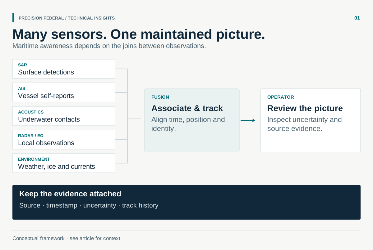
The fusion layer above it all carries the integration burden: one coherent picture assembled from radar detections, transponder reports, acoustic contacts, and environmental context, with provenance preserved so an operator can ask why the system believes what it believes. In practice this is where programs succeed or stall — not because any single algorithm is missing, but because joining real feeds, with real latencies and real failure modes, into one trustworthy picture is hard systems engineering.
Where software leverage concentrates — maritime sensing layers
Editorial weighting from public sources and practitioner reading — illustrative, not a measured statistic.
Evaluating maritime ML honestly
Every claim in this field should survive three questions. First, what is the false-alarm budget, and was performance measured against it — a detector scored only on recall is hiding its triage cost. Second, how does performance hold across conditions: sea state, latitude, sensor, season. A model demonstrated on calm mid-latitude scenes has not been demonstrated. Third, what happens at the long tail — small vessels, unusual geometries, rare behaviors — because the long tail is usually the mission.
Public benchmarks help, but the public record is also candid about their limits: label noise is real, ground truth at sea is expensive, and benchmark performance transfers imperfectly to operational feeds. The honest posture is to treat public datasets as the entry ticket and condition-stratified evaluation as the actual work.
Where small firms fit
The maritime picture is a stack of joined software problems, and that structure favors small teams with depth in one seam: a better detector with a disciplined false-alarm story, a tracker that survives congested straits, a triage interface that respects operator attention, a fusion service that treats provenance as a feature. Federal innovation programs across the Navy, the Coast Guard, and the transportation and research agencies fund exactly these seams, usually with public data available to prove feasibility before any government feed is granted. The firms that do well arrive with the evaluation discipline already in hand — because in this domain, the demo is easy and the distribution shift is not.
Bottom line
Maritime domain awareness stopped being a sensor problem and became a software problem, and the public record says so plainly — in the datasets released, the methods published, and the capabilities agencies keep asking for. The layers are known: radar from space, self-reports from transponders, acoustics below, radar and optics at the surface, environment all around. The awareness lives in the joins. That is where the engineering is, and where the next decade of federal investment in this domain is visibly headed.
Frequently asked questions
The effective understanding of activity on, above, and below the sea that could affect security, safety, the economy, or the environment. In practice it means a maintained, multi-sensor picture of vessel activity with the anomalies surfaced for human decision.
A vessel operating without transmitting on its identification transponder, whether by switching it off or by broadcasting false data. Detecting dark vessels means cross-checking independent sensing — usually satellite radar — against the self-reported picture.
The xView3-SAR release (Defense Innovation Unit and Global Fishing Watch, 2021) is the reference benchmark for dark-vessel detection, built on free Sentinel-1 radar imagery. Global AIS archives and public environmental and ice products round out the standard toolkit.
No. The published direction is pre-screening and prioritization — models that surface the most likely contacts so trained operators spend attention where it counts. Scarce labeled data and environment-to-environment shift keep the human firmly on the classification decision.